Biking and the Effect on Land Use
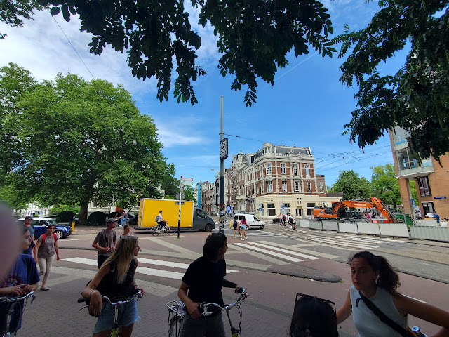
Focusing on examples seen in both Utrecht and Amsterdam, another takeaway of this trip is the land use patterns I have witnessed visiting these cities. What drew my eye throughout exploring the different places is the availability of space that allows one to feel safe traveling via any mode. While our group notably saw fewer segregated spaces between modes in the Netherland examples compared to Denmark, that does not mean they did not exist. In the image below, an intersection in Amsterdam about a five-minute walk east of our hostel, one can see how crossings provide a lane for bikes and pedestrians to travel, keeping them separated from car, bus, or tram traffic. The islands between the crossings keep pedestrians safe when waiting for cross-traffic to clear the pathway but the islands also narrow the vehicle lanes, slowing traffic through the intersection and thereby enhancing safety. Presented in the picture are bicyclists crossing the road in the bike lane, with oncoming cars moving slowly approaching the intersection, and myself, a pedestrian, safely out of the way on a wide sidewalk able to take a few photographs.
 |
| Bike and pedestrian crossing at an intersection in Amsterdam, the Netherlands |
Street redesigns, whether adding more bike parking or simply retrofitting the street for calmer vehicle traffic, can visually and spatially transform residential space. In one example (see below left), a two-way (yes, that is a two-way vehicular street!) calms traffic by narrowing the road with dozens of bike parking spaces and several inlets for vehicle parking, both residential and delivery vans. In addition, some parts of the sidewalk jut outward to form an edge and line the street, giving it complete form and providing some areas of green space that brightens the entire street with a more natural environment. Another example (below, right) also calms traffic but does not make the street as narrow comparatively. However, similar design elements tuck vehicle parking off the main travel area of the road, green spaces line the middle of the road to provide natural vegetation but also function to narrow the road reducing car speeds in front of houses, and entering the main road requires climbing a slightly upslope grade, further calming entering traffic.
 |
| Street design to support biking creates visually appealing residential spaces |
 |
| Elements in the street calm traffic where bikes and cars share the road |
Installing a bike network can have the effect of transforming land use by removing the paved element of a street and returning a natural landscape. Pictured below is one of the canals in Utrecht. On two of our bike tours, we were told that from about the 1970s to the 1990s, this stretch of the canal had been infilled to support the paving of a multi-lane freeway. Seen in the background is a mall built during the 1970s in a U.S.-mall style (connected to Utrecht Centraal station) and "naturally", a freeway would deliver customers to the mall. Yet, as the city turned away from car-centric planning and built the biking network throughout the city, calls from the residents grew louder to abandon the freeway and reclaim the canal. The city did follow suit and removed the barely mile-long concrete section of the unfinished freeway, restoring the canal and connecting it to the wider network that exists throughout Utrecht. Extensive construction of bike lanes and fietspads in the city allowed the city and its residents to spot the lack of utility the freeway served and restored a natural feature of the urban space, which as we saw in present-day serves for recreational boating and paddleboarding for Utrecht's residents and tourists.
These are but a few examples I noted about how the less space required for constructing bike lanes and protected cycle tracts frees land to be reclaimed for more bike parking, more green and public space, and offers potential for more development (i.e., housing in addressing one of our significant challenges in the United States).
 |
| Once a multi-lane freeway, the expanding bike network indirectly pushed the city to remove the freeway and refill the canal which transforms the urban fabric of this area in the central city |
Comments
Post a Comment